


Parishes of Tui
Our municipal area covers a total of eleven rural parishes, each with its own interesting spots worth a visit.
AREAS
This parish on the banks of the River Miño facing the Portuguese city of Valença is mentioned as early as the year 1112, when Queen Urraca grants this place to the Tui Church. Even further back than that, in 1095, a document mentions the hamlet of Anta, a place-name still in use which refers to a dolmen or megalithic burial mound.
The parish church was re-built in the 19th century but it was certainly older. Another noted building is the Bouzabalada manor house, with a chapel dedicated to Our Lady. The manor was re-built, as attested by an inscription in the entrance, in the year 1790.
By the road to Taborda, we can also find a forestry nursery founded in 1906 by the local forest engineer Rafael Areses. It houses a wealth of plant species, focusing particularly on trees.
Nowadays, in the areas of San Martiño and Gaios, we also have a mall and a business park, respectively.
BALDRÁNS
This parish, sometimes spelt Valdráns, is located on the banks of the river. Here we can find an interesting vestige of the human presence in ancient times: the rock carvings of As Carneiras, quite near the river, which display different kinds of petroglyph patterns (snake-forms, rings and cup marks).
The most prominent items of its architecture are the parish church, refurbished in the 17th and 18th centuries in the height of the Baroque style, and the Malladoura manor house, which has undergone quite a few modifications but still retains it stately bearing. In Baldráns we can find a rich ethnographic heritage comprising stone crosses, water mills, fishing posts, lavoirs and siphon pipes, which can be seen by the main road of the parish.
During the War of Independence, the French army took the area and burnt two altars in the church. Researcher Xulio Martínez Sigüenza collected an oral tradition connecting a place called “As Campas” with the location of a camp of the Napoleonic forces.
CALDELAS
The easternmost parish of Tui has a rich history. In this area, a beautiful bronze helmet was found in the river in 1976. It is attributed to the hillfort culture, with a chronology around the 4th century BC, and it is now exhibited in the Diocesan Museum. In the same spot in the river several bronze axes dating back to the 8th or 9th centuries BC were also found in 1983.
The first document reference to Caldelas is from 1301, when Fernando de Castro donated to the then Bishop of Tui, Juan Fernández de Soutomaior, his estate in Caldelas.
The present-day parish church of Saint Martin, built in 1965, keeps a bell-gable dated 1766 which was part of an earlier Baroque church that, in turn, had replaced an even older one, most probably Romanesque, built there, near the mouth of the River Caselas. Some historians consider the place-name Torre Vella (“Old Tower”) to be a reference to an old defence fortress, a counterpart to the Portuguese Tower of Lapela.
But the most salient element in Caldelas is what its very name means: hot springs, mentioned already in the 17th century. Ever since those days, people have come here to take therapeutic baths. The facilities included at first some sort of huts and, later on, wooden barracks. The building of the spa-hotel was paid in 1889 by Antonio Oliver Rubio, a general under King Alphonse XIII and owner of the springs. This spa then entered its prime, leading to the opening of several hotels and inns to lodge the many bathers. However, all that would change with the Civil War. Now, it has regained a lot of its life and splendour.
An important yearly event in Caldelas is the festival dedicated to Our Lady of the Rock, the last Monday of August, a charming celebration by the water, where families come to have a picnic dinner.
GUILLAREI
This is our rural parish with the biggest population and with one of the local industrial complexes. In the delimitation of the borders of Tui in the year 1095, some of its place-names are mentioned, such as Albelos and Sobredo, although the first document reference to Guillarei is from 1351, in a text from the Barrantes monastery, where the Bishop of Tui Don Gómez acknowledges a series of rights of the parish. In the A Torre area, there stood a fortress (hence the meaning of the name, “The Tower”) whose remains survived until the 19th century. The As Penizas hill was the location of several skirmishes and clashes with the French troops during the War of Independence.
One of the most salient historic events in Guillarei was the death of the Sobredo Martyrs, who were shot during a demonstration against the seizing of a farmer’s properties on 28 November 1922. This had such a strong impact that in 1932 a commemorative monument by the Vigo sculptor Camilo Nogueira was erected. The monument was demolished at the start of the Civil War but re-built in 1988. Every year a memorial is held in their honour.
The current parish church has a Neo-Classical style of the 19th century, the result of a refurbishment of its 18th-century predecessor. The most important parish festival is that of Our Lady of Sorrows, venerated in the Gándara chapel, which takes place on the third Sunday of September.
MALVAS
Its territory includes the Outeiro do Xudeu hillfort, attesting the settling of the area at least since the Bronze Age. The ancient name of the parish was Maloes de Jusaos, as mentioned in a 12th-century document where Ferdinand II grants this area to the monks of the Oia Monastery, who set up a farm to make use of these fertile lands. In 1287, King Sancho IV gave the parish freedoms and provided settlers to populate it. The old road from Tui to Baiona passed through Malvas and crossed the Way of Saint James, which came from Taborda.
The parish church is from the 18th century and it displays the coat of arms of the family Troncoso de Lira, the house responsible for its endowment.
PARAMOS
Another of our riverside parishes. Its first historic mention is from the year 1156. Later, in 1180, King Ferdinand II granted the Bishop of Tui half the church and territory of Paramos. Attesting the presence of nobility in the area, we still have the memory of the old Puntillón fortress.
On top of the As Penizas hill, as has been commented in Guillarei, several confrontations took place during the War of Independence, for which the French army took reprisal against the locals.
Besides a number of stone crosses, another example of the sculptor’s art stands out: the mausoleum of the Alejos family, now in the parish graveyard, after being moved here from the old Tui city cemetery.
PAZOS DE REIS
The history of this parish goes a long, long way back, as attested by the hillfort of Cabeza de Francos, also called Alto dos Cubos. This Bronze/Iron Age site was excavated for the first time in 1933 by Manuel Fernández-Valdés Costas, with later interventions in 1954 and, finally, 1997. There are two other hillfort settlements in Pazos de Reis: O Castelo, in Frinxo, and Pedras Brancas.
The top of Mount Aloia is surrounded by an impressively massive rampart with a perimeter of over three kilometres. The debate is still open among historians on the origins of this wall. For some, this is the legendary Mount Medulius, the last stronghold of anti-Roman resistance; for others, this was an ancient city, perhaps the early location of Tui itself.
The Monterreal area was where the Visigoth King Wittiza had his palace and court in the 8th century, when Tui was a prominent political centre where coins were minted.
Since the 20s, this parish has had its own self-ruling parish council, one of the few still remaining in Galicia.
Ecclesiastically, its churches are mostly linked to the central parish of Tui. They include the 17th-century Anxo Chapel, bearing the coat of arms of Bishop Diego de Torquemada, and the Chapel of the Sorrows, in Frinxo, built by Bishop Telmo Maceira around the middle of the 19th century.
The territory of Pazos de Reis includes Mount Aloia, a protected area since the 30s and a Natural Park since 1978. It is a place of great natural beauty and vast views of the valley below. Two religious pilgrimages are held yearly at the top: the Feast of Saint Julian, on 27 January, and that of Our Lady of the Sorrows, on the first Sunday of July. Several natural landmarks linked to local legends can be found, such as a large flat rock called “Saint Julian’s Bed”. More can be read about Mount Aloia in the section on this natural park.
PEXEGUEIRO
From the earliest mediaeval times, this parish has had a Benedictine monastery, mentioned on several occasions in different documents since the 10th century.
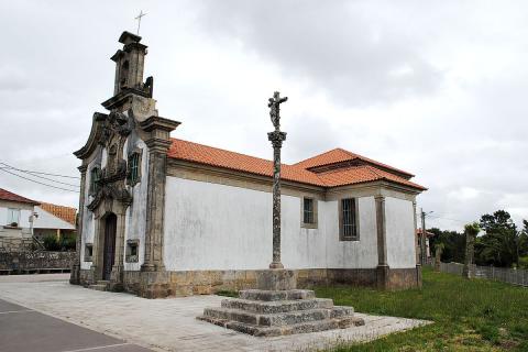
The parish church is a good example of Romanesque architecture and it was built in the 12th century. We can highlight its historiated capitals with plant motifs, its tympanum and its corbels, particularly the ones with bull heads on the South wall. Inside, the church keeps as many as five Baroque reredoses, recently restored. The sanctuary was re-built in 1765 by Bishop Juan Manuel Rodríguez Castañón, whose coat of arms can be seen in the outer side of the apse. It was here, in 1249, while preaching one of his sermons, that Saint Telmo announced his own imminent death.
As examples of other items of interest, in Pexegueiro we also have the old 16th-century rectory, now in ruins, and the mediaeval two-arched bridge on the River Furnia.
RANDUFE
Here we have several items of archaeological interest. In the first place, in the area of Alto do Coello, on the South and West slopes, we can find several petroglyphs or rock carvings, with rings, cup-marks, spirals, crosses… the most important of the carved rocks is the one called “Rozacús”. At the top of the slopes there is a series of saddle querns carved into the stone.
There is also the site of the Cotarel hillfort, in the A Guía neighbourhood, where the parish cemetery now stands. The hillfort was excavated in the 30s by José María Álvarez Blázquez.
The present-day parish church was in its origins a private chapel belonging to the heir of the Lords of Arcos, who had nearby their Pousa de Montenegro manor. Of the latter, only the entrance gate remains, with the coat of arms of the Pereira de Castro family. Paulo de Pereira de Castro and his wife María de Montenegro built a first chapel in 1603. Later, in 1789, Antonio Miguel de Montenegro e Soutomaior built a newer one, the work of the Tui stonemason Domingo Novás. In 1904, after being given by its owners, the chapel became the church of Saint Mary of A Guía.
We must not forget two other stately houses in Randufe: the first was Pousa do Bispo, also called Pousa das Sobreiras, built in the 16th and 17th centuries as the summer residence of the Bishop of Tui; it had an extensive estate, now a housing complex. The second was Pazo de San Xosé, or Pazo de Vista Alegre, built in the 18th century and later acquired by José Lago Maceira, the father of archbishop and Galician-language poet Manuel Lago González, who lived here during his childhood.
REBORDÁNS
This parish, whose name, according to Avila y Lacuela, comes from being in the borders of the city, was known in the early Middle Ages as “Espenicelo”. It has two main areas: the one known as Rebordáns proper and the San Bartolomé quarter, closest to the city centre, with the parish church.
Throughout the years, several archaeological remains of great importance for the history of Tui have been found here: Roman altars, columns, milestones, inscriptions… This is due to the neighbourhood of Santa Eufemia having been the site of an important Roman settlement, where a necropolis has been excavated.
The Church of Saint Bartholomew rises on this Roman necropolis, which is partly on display. This building dates back, according to some authors, to Visigothic times. It is mentioned in a document from the year 965 and was accompanied by a Benedictine monastery since the 11th century. It became the episcopal see when the latter was restored in 1069 under Bishop George and so it would remain until 1179, when Bishop Beltrán moved it to the new episcopal palace. The monastery would continue as such until 1435, when, due to its small size it was incorporated into the cathedral chapter.
The present-day church keeps its pre-Romanesque and Romanesque style, except for its portal, re-built in the 18th century. It has a basilical structure with a nave, two aisles and three apses. Among the decorative elements we can highlight the Romanesque capitals, some of them historiated, and the paintings of the sanctuary, from the late 16th century, which represent different scenes of the Passion of Christ.
The parish is crossed by the Portuguese Way of Saint James, which has in the Chapel of Our Lady of the Way (“A Virxe do Camiño”) one of its landmarks in Tui.
RIBADELOURO
This parish lies in the north side of the municipality, on the slopes of the Serra do Galiñeiro range. Despite the many archaeological findings linked to the earliest stages of human settlement in the area (Palaeolithic tools, heel axes, etc.) the first written reference is in a document from 1112 where this parish is referred to by the name of its patroness saint, Saint Columba (not to be confused with the male Irish saint of the same name). The present-day parish church is from 1827, when it was completely re-built on the same site as an earlier one, probably from Romanesque times.
Another esteemed monument in Ribadelouro is the Ponte das Febres (“bridge of the fevers”), crossed by the Way of Saint James, where Saint Telmo felt ill and decided to turn back to Tui, where he would die a few days later. There is one more mediaeval bridge: the Ponte de San Simón, on the stream bearing the same name.